The teaching and learning resources here all pertain to the basics of earthquake and tsunami hazards in Cascadia as featured in CEETEP workshops . Teachers on the Leading Edge, IRIS, and UNAVCO have even more resources on this topic. For presentations and other resources from a specific CEETEP workshop, visit our Workshops page.

Presentations

Presentation introducing fundamental concepts of Earthquake and Tsunami that are particularly tailored for the Pacific Northwest region (Cascadia). May be used either as learning aids for educators or edited for their own presentations. Associated animations are included as separate files.

Cascadia Earthquakes and Tsunami presentation

Associated animations:

Native American Indigenous Oral Histories and Disaster Preparedness presentation

Associated videos:

 Activities

sedimentary layers associated with great earthquake and tsunamiCascadia Tsunami Geology

The last megathrust Cascadia subduction zone earthquake occurred on January 26, 1700. Important evidence for this lies in geologic layers found along coastal Cascadia. In this guided-inquiry activity, learners examine a large photo of geologic layers that spectacularly records the 1700 megathrust Cascadia earthquake and tsunami.

 Activity Instructions

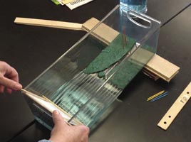
Investigating Tsunami Inundation Factorstsunami wave tank for student investigations

Students use tsunami wave tanks to learn about the effect that both near-coast bathymetry (submarine topography) and coastal landforms have on how a tsunami travels inland.

 Activity Instructions

sedimentary layers found in off-shore turbidite deposits can be simulated in a jar of mixed sediment sizesTurbidities in a Jar

Turbidity currents were formed when past Cascadia megathrust earthquakes shook the continental margin and sent torrents of sediment down submarine canyons and out onto the continental slope and rise. The resulting turbidite layers provide marine geologists with a record of past megathrust Cascadia earthquakes.  By modeling turbidite formation in a jar, learners can investigate how “graded beds” are formed by turbulent undersea landslides and mudflows (turbidity currents).

 Activity Instructions

use straw pieces to "drill" into a cupcake and try to determine the unseens layers withinCupcake Geology

This activity helps learners learn how sediment cores can be used to decipher geologic history by “coring” into a cupcake. In CEETEP, we relate this to cores of turbidite layers in ocean sediments giving record of past megathrust Cascadia subduction zone earthquakes but it is also widely applicable to many geological applications of coring. 

Activity Instructions

Pacific Northwest Fault Block ModelPacific Northwest Fault Block Model shows how the Pacific Plate drags the margin of the western North American plate northward leading to compression and earthquake hazard in the Seattle area.

Through this activity, learners can investigate the motions of crustal blocks in the Pacific Northwest and relate these to the tectonics of western North America. Paleomagnetic and GPS observations were used to determine how crustal blocks of this region slide past eachother. The resulting earthquakes that occur on crustal faults near or immediately beneath densely populated cities of Oregon, Washington, and British Columbia are a major risk.

Activity Instructions

Thunderbird and Killer Whale in traditional styleTsunami in Native American Oral Tradition 

Native Americans have been living in the Pacific Northwest for thousands of years and have experienced numerous megathrust Cascadia earthquakes. Because they are astute observers of landscape and nature, it is not surprising that Native Americans recorded these earthquakes and the accompanying tsunamis in their oral histories. This “activity” is a collection of resources that educators can use to connect their learners’ studies of Earth Science to history and culture by using Native Americans’ oral histories. 

Activity Resources

Information and Maps

Introduction to Pacific Northwest Plate Tectonics, Earthquakes, and Volcanoes

Document provides a brief (12 page) introduction to regional plate tectonics, earthquakes, and volcanoes of the Pacific Northwest. The focus is mainly on the subduction zone (coast to Cascade Mountains) because that is where most of the earthquakes and volcanoes occur, and where tsunamis can be generated.

Document

Pacific Northwest Tectonic Setting and Geology Poster

This poster includes maps of the physical geography, bedrock geology, physiographic provinces, and tectonics of Washington and Oregon.

Poster

Pacific Northwest Plate Tectonics Map and Cross-section

This CEETEP poster includes a schematic map and cross-section of Cascadia plate tectonics.

Poster